 Multiple Choice Questions
ASSERTION (A) : Chamge detection in remote sensing is the process of identifying differences in the state of an object or phenomenon.
REASON (R) : The use of GIS facilities for digital change detection.
Both (A) and (R) are true and (R) is correct explanation of (A).
Both (A) and (R) are true but (R) is not correct explanation of (A).
(A) is true , but (R) is false.
(A) is false , but (R) is true.
The scale on the aerial photography is variable on account of which of the following ?
Shadows of the objects
Texture of the objects
Relief of the ground
Shadows and relief both
Carta-Marina is
A cartographic instrument used by Arab geographers.
A book authored by Al-Masudi.
A map America prepared by Wald Simular.
An age succeeding to "Age of Discovery".
ASSERTION (A) : There are data restrictions in using Lorenz Curve since variable must be expressed as frequencies and negative values cannot be included.
REASON (R) : This technique is difficult to be applied to study of continuous variables.
Both (A) and (R) are true and (R) is the correct explanation of (A).
Both (A) and (R) are true but (R) is not the correct explanation of (A).
(A) is true , but (R) is false.
(A) is false , but (R) is true.
ASSERTION (A) : Partial correlation is a method of dealing with three or more variables.
REASON (R) : Basically, it is the correlation between two variables holding the third variables constant.
Both (A) and (R) are true and (R) is the correct explanation of (A).
Both (A) and (R) are true but (R) is not the correct explanation of (A).
(A) is true , but (R) is false.
(A) is false , but (R) is true.
Which one of the following diagrams can be used to represent non-spatial attribute data ?
Flow line
Bars and Cubes
Choropleth
Isoline
B.
Bars and Cubes
Which one of the following correlation coefficients is mismatched with its value ?
Perfect positive r = ± 1.0
Imperfect negative r = -1.0
No correlation r = 0.0
Positive significant r = 0.5 < 1.0
|
LIST I (Sat. Sensors) |
LIST II (IFOV - Pan) |
| (a) IRS - IC LISS II | (1) 0.61 cm |
| (b) SPOT - 5 HRV | (2) 5.80 cm |
| (c) DG - Quick Bird-2 | (3) 8.00 cm |
| (d) ADEOS AVNIR | (4) 5.00 cm |
a-4 , b-2 , c-3 , d-1
a-2 , b-4 , c-1 , d-3
a-1 , b-2 , c-3 , d-4
a-2 , b-1 , c-4 , d-3
|
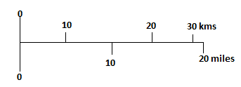
LIST I (Types of Scale) |
LIST II (Scale on map) |
| (a) Statement | (1) 1: 25,000 |
| (b) Simple Linear | (2) 1 inch to 1 mile |
| (c) Representative fraction | (3) |
| (d) Comparative scale | (4) |
a-2 , b-4 , c-3 , d-1
a-1 , b-2 , c-3 , d-4
a-4 , b-1 , c-2 , d-3
a-2 , b-4 , c-1 , d-3
Amon the following satellite series , which has the oldest remote sensing programme ?
IRS Series
SPOT series
LANDSAT Series
NOAA Series
