 Multiple Choice Questions
Which one of the following scales is correctly measure the rank-size distribution of settlements ?
Nominal
Ordinal
Interval
Ratio
Who among the following archietect-planner prepared Master Plan for Chandigarh city?
Charles Correa
Frank Lloyd Wright
Edwin Lutyens
Le Corbusier
ASSERTION (A) : The partition of Inida in 1947 provided an impetus for town planning activities in the country.
REASON (R) : Resettlement of displaced persons and providing them employment opportunities created a big opportunity before the town planners to construct new town and make provision of amenities and facilities in existing towns especially in north Indian states.
Both (A) and (R) are true and (R) is the correct explanation of (A).
Both (A) and (R) are true, but (R) is not the correct explanation of (A).
(A) is true but (R) is false.
(A) is false , but (R) is true.
|
LIST I (Name of the city) |
LIST II (Period of being planned) |
| (a) Kanchipuram | (i) Post-independence |
| (b) Jaisalmer | (ii) Colonial |
| (c) Kodaikanal | (iii) Medieval |
| (d) Bhilai | (iv) Ancient |
(a)-(i) , (b)-(ii) , (c)-(iii) , (d)-(iv)
(a)-(ii) , (b)-(iii) , (c)-(iv) , (d)-(i)
(a)-(iii) , (b)-(iv) , (c)-(i) , (d)-(ii)
(a)-(iv) , (b)-(iii) , (c)-(ii) , (d)-(i)
Which he one of the following statements correctly depicts threshold according to the Central Place Model ?
Point at the consumer movement is minimum.
Distance far which consumer will travel for a service.
Minimum number of people needed to support a service.
Economic base of a service centre.
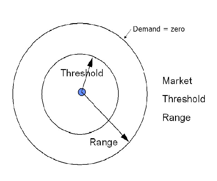
Which one of the following Models is explained by the given figure below ?

Weber's Model
Central Place Model
Von Theunan Model
Gravity Model
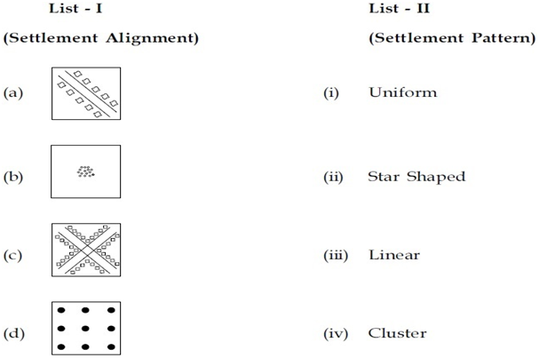
Match LIST I with LIST II and select correct answer from the code given below :

(a)-(ii) , (b)-(iii) , (c)-(iv) , (d)-(i)
(a)-(iii) , (b)-(iv) , (c)-(ii) , (d)-(i)
(a)-(i) , (b)-(ii) , (c)-(iii) , (d)-(iv)
(a)-(iv) , (b)-(iii) , (c)-(ii) , (d)-(i)
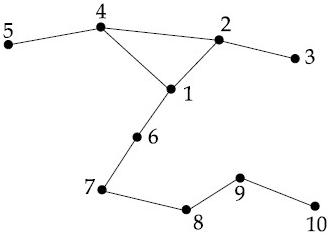
Which one of the following code is correct in showing number of vertices , edges and diameter for the given network ?

| VERTICES | EDGES | DIAMETER |
| 10 | 7 | 5 |
| VERTICES | EDGES | DIAMETER |
| 10 | 10 | 7 |
| VERTICES | EDGES | DIAMETER |
| 10 | 5 | 6 |
| VERTICES | EDGES | DIAMETER |
| 10 | 8 | 7 |
B.
| VERTICES | EDGES | DIAMETER |
| 10 | 10 | 7 |
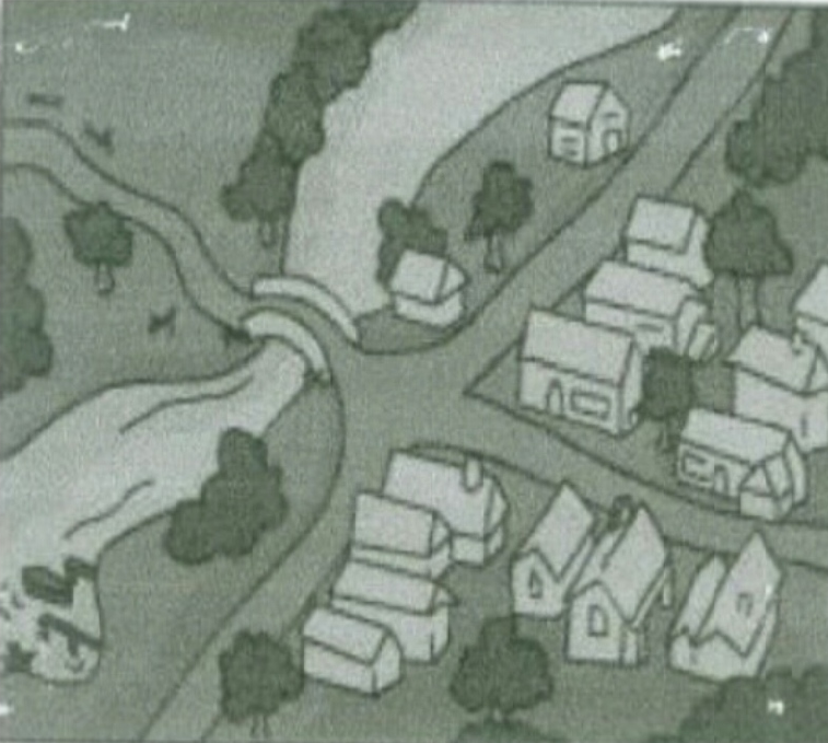
Which one of the following human settlement sites is representative of the following figure ?

Defence settlement site
Dry point settlement site
West point settlement site
Bridging point settlement site
ASSERTION (A) : The city plans in ancient India were laid down in accordance to some preconceived ideas with high standards of public health.
REASON (R) : This does not, however, reflect the concern of ancient India for community sanitation and health.
(A) is true , but (R) is false.
(A) is false , but (R) is true.
Both (A) and (R) are true and (R) is the correct explanation of (A).
Both (A) and (R) are true but (R) is not the correct explanation of (A).
