 Short Answer Type
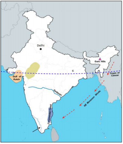
On an outline map of India provided:
(a) Draw and name the Tropic of Cancer.
(b) Label the river Godavari.
(c) Mark and name the Garo Hills.
(d) Mark C on the coal fields of Jharia.
(e) Mark with an arrow and name the NE monsoon over the Bay of Bengal.
(f) Shade and name the Gulf of Kutch.
(g) Shade and name the coastal plain that receives rainfall in October and November.
(h) Mark with a dot and name Delhi.
(i) Shade a region with Black Cotton Soil.
(j) Use an arrow to point at a densely populated state in South India.

Name the tree as per the characteristics given below:
The wood is hard and suitable for ship building
Name the natural vegetation found in the following regions:
(i) The western slopes of the Western Ghats
(ii) The Nilgiris
(iii)Western Rajasthan
Give one geographical reason for each of the following:
(i) Sprinkler irrigation is practiced in arid and semi-arid regions.
(ii) A tube well should be installed in a fertile and productive region.
(iii) Canal irrigation is more suitable in the Northern Plains.
Study the diagram below and answer the questions that follow:
(i) Name the activity shown in the diagram.
(ii) Give two objectives of the activity named in (i).
