 Multiple Choice Questions
Which of the following was the earliest regional planning exercise in India ?
National Capital Region Plan
Dandakaranya Area Plan
Damodar Valley Project
Bhakra-Nangal Project
Which of the following is an incorrect plan ?
Utilitarian Planning - Functional Planning
Comprehensive Planning - Integrated Planning
Regional Planning - Spatial Planning
Sectoral Planning - Co-ordinated Planning
ASSERTION (A) : Laterite soils are well developed in Kerala.
REASON (R) : Kerala receives high rainfall during monsoon season.
(A) and (R) are correct and (R) explains (A).
(A) is correct , but (R) is false.
(A) is false , but (R) is correct.
(A) and (R) are correct , but (R) does not explains (A).
ASSERTION (A) : Himalayan rivers are perennial.
REASON (R) : The region gets rainfall from the South West monsoon season only.
(A) and (R) are correct and (R) explains (A).
(A) and (R) are correct but (R) does not explains (A).
(A) is correct , but (R) is false.
(A) is false , but (R) is correct.
The "Valley of Kashmir" lies between which of the following ranges ?
Pir-Panjal and Karakoram range
Pir-Panjal and Zaskar range
Zaskar and Ladakh range
Sulaiman and Kirthar range
Which one of the following regions has the highest proportion of agricultural land under irrigation ?
Punjab-Haryana Plain
Rajasthan-Gujarat Plan
West Bengal Delta
Uttar Pradesh-Bihar Plan
Consider the following figures as X AND Y respectively :
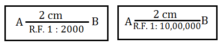
Fig X is small scale and the distnce between A and B is 40 metres
Fig Y is large scale and the distnce between C and D is 4 km
Fig X is large scale and Fig Y is small scale. The distance between A and B and C and D are 40 metres and 20 km respectively.
Fig X is alrge scale and Fig Y is small scale . The distance between A & B and C & D are equal.
C.
Fig X is large scale and Fig Y is small scale. The distance between A and B and C and D are 40 metres and 20 km respectively.
If the variability of rainfall is to be measured , which of the following techniques will be used ?
Mean Deviation
Standard Deviation
Co-efficient of Variation
Interquartile Range
Which of the following is not a Quantitative Distribution Map ?
Choroschematic Map
Isopleth Map
Dot Map
Choropleth Map
Occupational structure of population in India at state level is best represented by :
Dot Method
Isopleth
Choropleth
Pie Diagram


 Switch


