zigya tab

Study the extract from the topographical sheet No. 63K/12, as shown in the figure below and answer the following questions :
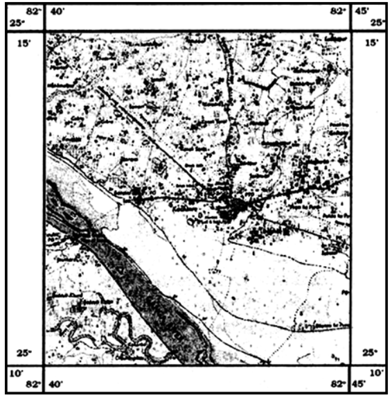
  1. Convert 1: 50000 into a statement of scale.
  2. Name the major settlements of the area.
  3. What is the direction of flow of the river Ganga?
  4. At which one of the banks of river Ganga, Bhatauli is located?
  5. What is the pattern of rural settlements along the right bank of river Ganga?
  6. Name the villages/ settlements where Post Office / Post and Telegraph Office are located.
  7. What does the yellow colour in the area refer to?
  8. What means of transportation is used to cross the river by the people of Bhatauli village?


  1. 1 cm represents 50000 cm or 500 metre. 1 cm represents 500 metres.
  2. Mirzapur and Varanasi.
  3. The Ganga flows to the south-east.
  4. Bhatauli is located on the south bank of Ganga.
  5. Scattered.
  6. Touli
  7. Cultivation area
  8. Ferry.
554 Views

 If you are interpreting cultural features of a topographical sheet, what information would you like to seek and how would you derive this information? Discuss with the help of suitable examples.

 The cultural features are settlements, railway and roads, buildings. These features and their distribution pattern help in understanding the area. We will seek the information about these features. The information on means of transport and communication is sought from the given sheet through the questions such as : What are the means of transport in the region? How adequate are they ? And are there post office and telephone lines ? etc.

The next information will be derived about human settlements. This information will indicate the occupation, the land use etc., we will come to know that how many urban centres and industrial centres are there? How dense are the rural settlements? Are they uniformly distributed ? Nucleated settlements with uniform

distribution occur in relatively flat alluvial plains as in Uttar Pradesh. Along the coastal plains in Kerala we find linear pattern of settlements following old sand dense parallel to the coast.

299 Views

Study the extract for topographical sheet 63K/12 shown in the figure below and answer the following questions :
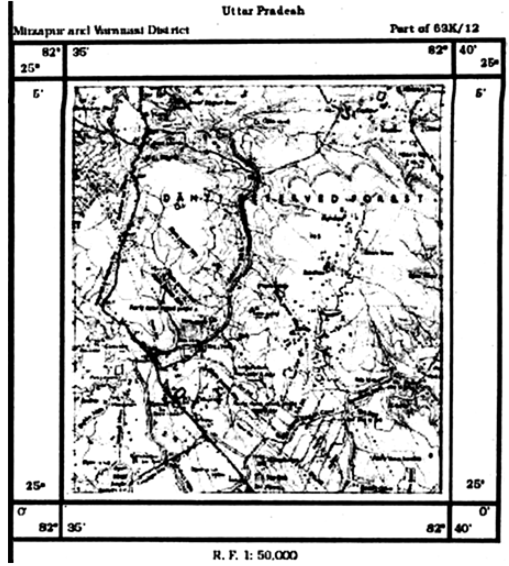
  1. Give the height of the highest point on the map.
  2. River Jamtihwa Nadi is flowing through which quarter of the map?
  3. Which is the major settlement located in the east of the Kuardari Nala ?
  4. What type of settlement does the area have?
  5. Name the geographical feature represented by white patches in the middle of Sipu Nadi.
  6. Name the two types of vegetation shown on part of the topographical sheet.
  7. What is the direction of the flow of the Kuardari?
  8. In which part of the sheet area is Lower Khajuri Dam located?


  1. 200m
  2. Jamtihwa Nadi flows in the south-east corner.
  3. Village settlements scattered.
  4. The area has scattered settlements.
  5. Plain
  6. Deciduous forests and thorny vegetation.
  7. To south-west
  8. In the north.
247 Views

Advertisement

Draw the conventional signs and symbols for the following features :

(i) International Boundary (ii) Bench Mark (iii) Villages (iv) Metalled Road (v) Footpath with Bridge (vi) Places of Worship (vii) Railway line.


821 Views

Advertisement

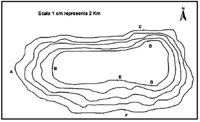
Study the contour pattern and answer the following questions :

1. Name the geographical feature formed by contours.

2. Find out the contour interval on the map.

3. Find out the map distance between E and F and convert it into the ground distance.

4. Name the type of slope between A and B; C and D and E and F.

5. Find out the direction of E, D and F from G.

  1. Plateau
  2. 100 m.
  3. 2 cm. Ground distance is 4 km.
  4. Between A and B slope is gentle. Between C and D is irregular. Between E and F is gentle.
  5. From G the direction of E is north-west, D is on the North and F is in South.
276 Views

Advertisement